Cerro de Punta
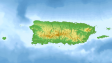
Highest peak in Puerto RicoCerro de Punta or Cerro Punta is the highest peak in Puerto Rico, rising to 1,338 meters (4,390 ft) above sea level. The mountain is part of the Cordillera Central and is located on the town boundary between the municipalities of Ponce and Jayuya in the central region of the main island of Puerto Rico.
Read article
Top Questions
AI generatedMore questions
Nearby Places

Cordillera Central (Puerto Rico)
Main mountain range in Puerto Rico

WPUC-FM
Radio station in Ponce, Puerto Rico

Monte Jayuya
Mountain in Puerto Rico
Hacienda Gripiñas
Restored nineteenth-century coffee plantation in Jayuya, Puerto Rico

Anón
Barrio of Ponce, Puerto Rico

Veguitas, Jayuya, Puerto Rico
Barrio of Puerto Rico

Zamas, Jayuya, Puerto Rico
Barrio of Puerto Rico
Piedra Blanca (Puerto Rico)
Mountain in Puerto Rico


